23.  Measure Distance
Draw a measurement line after selecting Measure Distance from here in the map context menu
or doing a Ctrl+Click in the map.
Click a second time to finish the measurement and fix the line.
See User Features in the map legend for more information.
All measurement lines are saved and will be restored on next start up.
Remove the lines by Ctrl+Click on the hotspot (small cross at the end) or by right clicking on
the hotspot and selecting Remove User Feature.
You can use the keyboard, mouse wheel or the map overlays to scroll and zoom while dragging a line.
Right-click, press the escape key or click outside of the map window to cancel the measurement line editing.
Measurement lines use nautical miles, kilometers or statue miles as unit. Feet or meter will be added as unit if the lines are short enough.
A great circle gives the shortest distance from point to point on earth but does not use a constant course. For that reason the measurement line will show two course values. One for the start and one for the end position if they are different. Short lines have mostly equal start and end course.
The width of distance measurement lines can be changed in the options dialog on page Map User. The labels on the options page Map Labels.
A measurement line starting at a VOR, VORDME, VORTAC or TACAN takes the calibrated declination of the navaid to calculate the magnetic course. See also Magnetic Declination for more information about magnetic declination.
The display of measurement lines is automatically enabled in menu View -> User Features ->
Measurement Lines after adding a line.
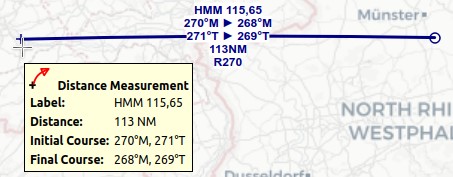
Little Navmap shows a tooltip with information about the measurement line when hovering the mouse above the hotspot (cross at line end).

A measurement line with all labels enabled starting at VOR HMM (not shown on the right).
Labels shown are navaid ident and frequency, magnetic start and end course, true start and end course, distance and VOR radial.
Tooltip with cross mouse cursor at the hotspot.