40.  Tracks
Tracks are a structured set of flight routes that stretch across the Atlantic, Pacific or Australia.
Little Navmap can download, display and use the following tracks:
NAT: North Atlantic Tracks
PACOTS: Removed as of 3.0.18 since the DINS Query page is no longer publicly available.
AUSOTS: Removed as of 3.0.18 since discontinued.

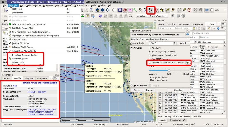
Image showing all track related functions in Little Navmap. Click image to enlarge.
Important
You need updated and complete navdata to read the tracks correctly.
This is either the MSFS or the updated Navigraph or X-Plane scenery libraries.
Install the latest Navigraph navdata update and use the options Select automatically, Use Navigraph for all Features or
Use Navigraph for Navaids and Procedures in the menu Scenery Library -> Navigraph.
40.1. Download
Tracks are not downloaded periodically since changes in the track system can break flight plans. You can choose to download tracks on startup or download them manually.
Download on startup and immediate can be enabled in the menu Flight Plan -> Download Oceanic Tracks on Startup.
Manual download can be started in the menu Flight Plan -> Download Oceanic Tracks.
You can select the track systems to download in the sub-menu track-sources in the menu Flight Plan.
The download will start again after changing sources.
The track database is cleared on startup if Download Oceanic Tracks on Startup is not selected.
40.2. Map Display and Information
Tracks are mostly used like airways. They respond to mouse click, tooltip and can be highlighted
from the information window on tab Navaids.
Tracks can be enabled for map display in the toolbar or menu View using ![]() Show Oceanic Tracks.
Show Oceanic Tracks.
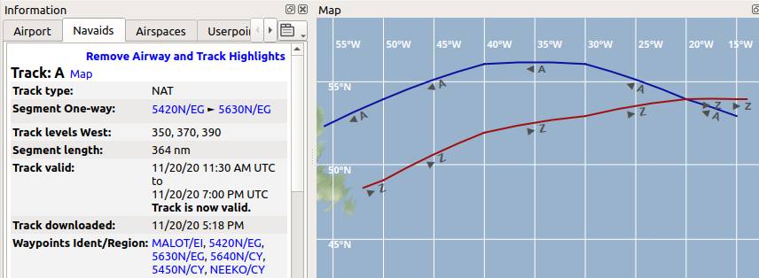
NAT tracks are shown in dark red color if eastbound and in dark blue color if westbound.

NAT tracks A and Z. Information for track A shows flight levels 350, 370 and 390.
40.3. Flight Plan Calculation and Editing
You have to check Use NAT tracks in the flight plan calculation window to use tracks. The track will be used by Little Navmap if the settings allow this and the track is between departure and destination.
See Flight Plan Calculation for more information.
Little Navmap will not keep you from creating invalid routes where you leave a track early or switch to a track. Valid flight plans can only be ensured by using the flight plan calculation.
Note
You have to use the correct cruise flight altitude in your flight plan. This has to match the track levels shown in the information window. Otherwise, the track will not be used.
40.4. Export
Track information is saved for flight plans in Little Navmap’s LNMPLN format (Little Navmap LNMPLN Format).
It can happen that Little Navmap shows errors when a plan is reloaded later with different or missing tracks. Calculate the flight plan again to use the changed tracks.
All other exported flight plan formats for simulators, aircraft and tools will not receive track information but only a list of waypoints extracted from the track. This should allow to load the flight plans into all add-ons without issues.